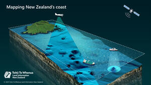
Stylised rendering of Tuhua (Mayor Island) in the Bay of Plenty.
The data will be used to create detailed 3D maps of the coast and adjacent seafloor, providing a baseline from which we can measure changes to coastal areas in the future. For example, from climate events and natural hazards such as tsunami and earthquakes.
This mapping will help decision-makers keep communities and infrastructure safe and protect ocean biodiversity through improved habitat mapping.
Over the next three years the programme will map up to 40% of New Zealand’s coastline. The areas to be mapped are highly populated parts of the coastline, as well as areas with significant coastal infrastructure, and where there is a higher risk of coastal inundation.

Mapping data will be collected using various techniques, including by planes fitted with high-resolution airborne Light Detection and Ranging (LiDAR) scanning equipment.
The 3D Coastal Mapping programme began in late 2023 with the installation of global positioning receivers at 10 existing tide gauge sites around the coast. These will measure how the land moves to better understand the impact of sea-level rise over time.
Coastal mapping began in April 2024 in the Bay of Plenty and near Invercargill, and will continue over the next three years.
A budget of $30.2 million of total funding supports this work.
LINZ will also use data collected to update nautical charts for marine safety, a core part of our Hydrographic work programme.