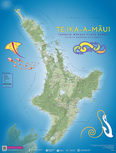
This map shows the place names given by tangata whenua throughout Te Ika-a-Māui, before European settlement

This is a smaller PDF file, designed to be viewed on screen.
High resolution files
Note: these are large files and may take several minutes to download.
The names shown on this map have been sourced from:
- the 1st editions of Te Ika-a-Māui and Te Wai Pounamu circa 1840 maps published in 1995 by the Department of Survey and Land Information for Ngā Pou Taunaha o Aotearoa New Zealand Geographic Board
- Treaty of Waitangi claims’ settlements
- feedback from various iwi and hapū of Aotearoa New Zealand
The cartography is a best attempt to represent the landscape as it was in the 19th century. This map is at a scale of one to a million so not all known tangata whenua place names were able to be included – only those that are the most prominent or culturally significant. Space limitation on the back of the maps meant the kōrero where known is brief.
For further information about any of these names or for other Aotearoa New Zealand place names please see the New Zealand Gazetteer. For comments and feedback on the maps and/or names, please contact the Board at NZGBenquiries@linz.govt.nz. Changes can be made in the next revisions and/or editions of the printed maps, and periodically in the digital versions.