Overview
When defining parcels restricted in height such as a tunnel or the subdivision of a multi storey building, the horizontal and vertical extent of each parcel must be depicted on the survey and title diagrams (r 83(a), (d), (e)(i) and r 97(1)(a)). All parcels must be captured in Landonline.
Landonline does not permit parcels with the same topology class to overlap; therefore, primary parcels must be captured separately in either the ‘Primary’ or ‘Strata’ topology layer as follows. Some parcels will require boundary vector capture while others won’t. Non-overlapping parcel(s) substantially at ground level must be captured with a ‘Primary’ topology class. Parcels either immediately vertically above or below the parcel at ground level (touching the parcel at ground level or sharing the same RL) must be captured with a ‘Strata’ topology class. These parcels are referred to as strata parcels in Landonline. More than one parcel can be created with a ‘Strata’ topology, providing they don’t overlap horizontally.
If there is another height-limited primary parcel anywhere vertically above or below the strata parcel, it must be captured as an aspatial parcel and defined on a plan graphic (Standard for lodgement of cadastral survey datasets section 4.4(c)).
Similarly, non-primary parcels must be captured separately in either the ‘Secondary’ or ‘Tertiary’ topology layer as follows. The non-overlapping height limited non-primary parcels substantially at ground level must be captured with a ‘Secondary’ topology class. Parcels immediately vertically above or below the parcel at ground level (touching the parcel at ground level or sharing the same RL) must be captured with a ‘Tertiary’ topology class. More than one parcel can be created with a ‘Tertiary’ topology, providing they don’t overlap horizontally.
If there is another height-limited non-primary parcel vertically above or below the tertiary parcel, it must be captured as an aspatial parcel and defined on a plan graphic (Standard for lodgement of cadastral survey datasets section 4.5(b)).
Note that unit title, company lease or cross lease parcels do not need to be captured (Standard for lodgement of cadastral survey datasets section 4.2.2(a)).
Steps to capture height-limited primary parcels
- Capture ground level parcels as primary parcels
Parcel Intent: Fee Simple Title or Legalisation
Topology Class: Primary
Area: Area must be captured
Vector Layer: 1 - Pri or 97-Pri, Str where primary and strata parcel boundaries coincide
- Capture parcels immediately either above or below ground level as strata parcels
Parcel Intent: Fee Simple Title or Legalisation
Topology Class: Strata
Area: Area must be captured
Vector Layer: 7 - Str
- All other height-limited parcels that are not represented at ground level and immediately either above or below ground level must be captured as aspatial parcels and depicted on a plan graphic
Parcel Intent: Fee Simple Title or Legalisation
Topology Class: No Topology
Area: Areas can be captured for aspatial parcels
Vector Layer: Not applicable, depicted on plan graphic only
Steps to capture height-limited non-primary parcels
- Capture ground level non-primary parcels as secondary parcels
Parcel Intent: Easement or Covenant - Land
Topology Class: Secondary
Vector Layer: 2-Sec
- Capture height-limited non-primary parcels immediately either above or below ground level as tertiary parcels
Parcel Intent: Easement or Covenant - Land
Topology Class: Tertiary
Vector Layer: 5-Ter
- All other height-limited non-primary parcels must be captured as aspatial parcels and depicted on a plan graphic
Parcel Intent: Easement or Covenant - Land
Topology Class: No Topology
Vector Layer: Not applicable, depicted on plan graphic only
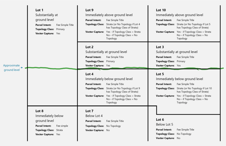
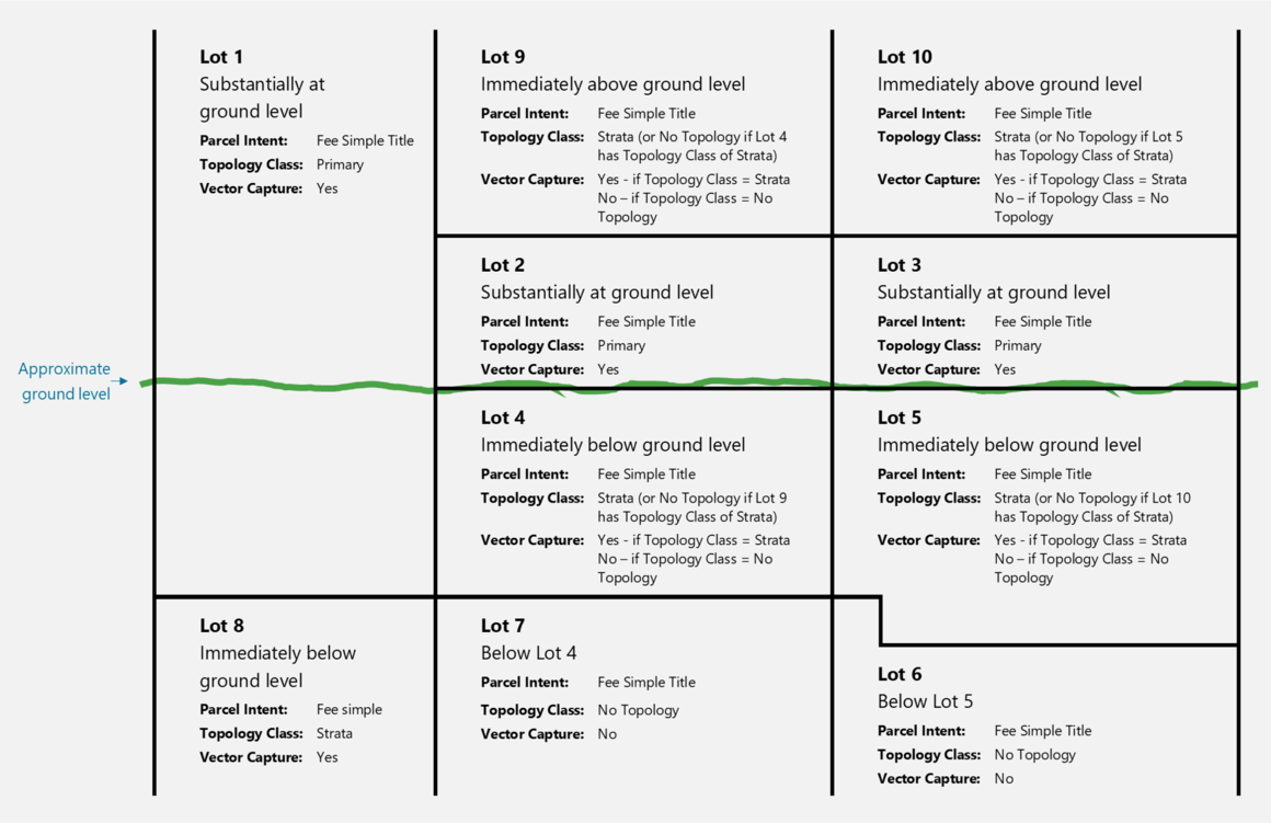
Figure 1 below illustrates the Landonline capture requirements for height-limited primary parcels. Lots 1, 2 and 3 are substantially at ground level hence they are captured in the ‘Primary’ topology layer and with vector capture. Lots 4 and 5 are immediately vertically below ground level Lots 2 and 3 respectively. Conversely Lots 9 and 10 are immediately vertically above Lots 2 and 3 respectively. The surveyor may choose either the below set of Lots 4 and 5 or the above set of Lots 9 and 10 (but not both sets) to be in the ‘Strata’ topology layer and with vector capture. The set of lots not chosen to be in the ‘Strata’ topology layer will then be either lots above or below a strata parcel hence they must be captured as aspatial parcels and depicted in a plan graphic.


Figure 1: Vertical view of lots 1 to 10 to illustrate Landonline capture requirements