Overview
There are specific aspects that need to be considered for parcels of land that have a tidal water boundary, or which are wholly or partly in the marine and coastal area or coastal marine area. These include:
- ensuring that all of the land to the existing legal boundary is accounted for
- determining whether any land is required by the Marine and Coastal Area (Takutai Moana) Act 2011 (MACAA) or the Resource Management Act 1991 (RMA) to be shown as being or becoming common marine and coastal area
- whether any other legislation is relevant, for example the Manukau Harbour Control Act 1911.
For water boundaries that are not tidal, or for general information on water boundaries refer to:
Water boundaries
Key terms and abbreviations
means the foreshore, seabed, and coastal water, and the air space above the water—
(a) of which the seaward boundary is the outer limits of the territorial sea:
(b) of which the landward boundary is the line of mean high water springs, except that where that line crosses a river, the landward boundary at that point shall be whichever is the lesser of—
(i) 1 kilometre upstream from the mouth of the river; or
(ii) the point upstream that is calculated by multiplying the width of the river mouth by 5
means the marine and coastal area other than—
(a) specified freehold land located in that area; and
(b) any area that is owned by the Crown and has the status of any of the following kinds:
(i) a conservation area within the meaning of section 2(1) of the Conservation Act 1987:
(ii) a national park within the meaning of section 2 of the National Parks Act 1980:
(iii) a reserve within the meaning of section 2(1) of the Reserves Act 1977; and
(c) the bed of Te Whanga Lagoon in the Chatham Islands
(a) means the area that is bounded,—
(i) on the landward side, by the line of mean high-water springs; and
(ii) on the seaward side, by the outer limits of the territorial sea; and
(b) includes the beds of rivers that are part of the coastal marine area (within the meaning of the Resource Management Act 1991); and
(c) includes the airspace above, and the water space (but not the water) above, the areas described in paragraphs (a) and (b); and
(d) includes the subsoil, bedrock, and other matter under the areas described in paragraphs (a) and (b)
MHWM
mean high water mark
MHWS
mean high water springs
for the purpose of defining the landward boundary of the coastal marine area, means the mouth of the river either—
(a) as agreed and set between the Minister of Conservation, the regional council, and the appropriate territorial authority in the period between consultation on, and notification of, the proposed regional coastal plan; or
(b) as declared by the Environment Court under section 310 upon application made by the Minister of Conservation, the regional council, or the territorial authority prior to the plan becoming operative,—
and once so agreed and set or declared shall not be changed in accordance with Schedule 1 or otherwise varied, altered, questioned, or reviewed in any way until the next review of the regional coastal plan, unless the Minister of Conservation, the regional council, and the appropriate territorial authority agree
means any land that, immediately before the commencement of this Act, is—
(a) Maori freehold land within the meaning of section 4 of Te Ture Whenua Maori Act 1993; or
(b) set apart as a Maori reservation under Te Ture Whenua Maori Act 1993; or
(c) registered under the Land Transfer Act 2017 and in which a person other than the Crown or a local authority has an estate in fee simple that is registered under that Act; or
(d) subject to the Deeds Registration Act 1908 and in which a person other than the Crown or a local authority has an estate in fee simple under an instrument that is registered under that Act
Accounting for the whole of the parcel
Care needs to be taken to define the correct legal boundary when resurveying land with a tidal water boundary.
All land in an existing primary parcel being extinguished must be included in one or more new primary parcels, residue parcels, or balance parcels (r 39(2)). This means that all of the land to the existing water boundary must be accounted for, even when a new water boundary is required to be created landward of the existing water boundary.
To enable the whole of a parcel to be accounted for, the original legal description needs to be determined. In addition to the information below, please see 'Where to start' in the Water boundaries article for more information:
Where to start
There are various legal descriptions that can define a tidal water boundary. The most common are mean high water springs (MHWS) and mean high water mark (MHWM).
Generally, where land is bounded by a tidal water boundary (such as the sea or a tidal river or creek), the position of the tidal water boundary has in the past been taken as MHWM in absence of other evidence (s 35 of the Crown Grants Act 1908).
MHWS has been used more recently and some surveys are required to remove land below MHWS.
Where the existing legal boundary of the land under survey is MHWM, it continues to be MHWM (unless previously changed by legislation such as the Manukau Harbour Control Act 1911). When a survey is undertaken all of the land to MHWM must be accounted for (regardless of whether a new MHWS boundary is required to be created for a portion of a parcel that has become or is becoming common marine and coastal area). The diagram below illustrates accounting for all of the land to the existing boundary when a new boundary is required to be created at MHWS.
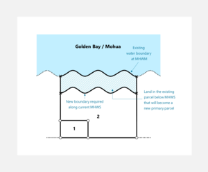
Figure 1: Accounting for the whole parcel
In some circumstances, legislation apart from the RMA/MACAA may have removed land below MHWS from the title. The Manukau Harbour Control Act 1911 is one such piece of legislation. This Act vested all of the land beneath mean high water springs in the Manukau Harbour Board. On 23 August 1967 the Auckland Harbour Board (as successor of the Manukau Harbour Board) raised a title for the land vested in it. That title is NA9B/1172 (see also SO 67474). Surveys of land in the area should investigate the effect of that Act on the land under survey as it is likely that the legal boundary is now MHWS despite originally going to MHWM.
Boundaries that could otherwise be accepted, may need further evaluation. For further information on accepted boundaries see:
Tidal boundaries may not be able to be accepted
Note that:
- when an esplanade reserve is set aside from land with a tidal boundary which is being subdivided, the esplanade reserve can only go to MHWS – refer section 230 RMA
- a CSD with a tidal boundary that is prepared solely to support the removal of limitations as to parcels from the title should account for all land to the existing legal boundary. This is likely to be MHWM (unless the original grant was not to MHWM or the applicant had lost possession of part of the land in the limited title). For more information on uplifting limitations for a parcel that has a water boundary see:
When limitations as to parcels are being uplifted - a CSD that is prepared solely to claim accretion to land with a tidal boundary should account for all land to the new position of the legal boundary. That is, if the existing legal boundary is MHWM, accretion will extend to the current line of MHWM. The same concept applies to a survey showing erosion.
Tidal boundaries may not be able to be accepted
In some cases an existing tidal boundary will not be able to be accepted under rule 15 because of specific legislation, including where:
- parcels of common marine and coastal area need to be created along the boundary due to statutory requirements of the MACAA or the RMA
- the Manukau Harbour Control Act 1911 (or other similar legislation) has removed land below MHWS from the parcel.
The Surveyor-General does not have statutory powers to waive the requirements of these statutes either by rule or dispensation.
If there is no statutory requirement to identify common marine and coastal area or to update a boundary to reflect the effect of other legislation such as the Manukau Harbour Control Act 1911, the tidal boundary may be able to be accepted.
For further information about accepting water boundaries, see:
Accepting water boundaries
Common marine and coastal area
The remainder of this article relates to determining the extent of land that is to become common marine and coastal area in a cadastral survey dataset (CSD), and how that land is to be recorded.
It is comprised of the following sections:
- Requirement to identify common marine and coastal area
- Land becoming common marine and coastal area under s 237A of the RMA upon subdivision
- Where Crown or local authority owned land has become common marine and coastal area (s 11 or s 13 MACAA)
- Identifying common marine and coastal area where land is being acquired by Crown or local authority
- Easements over land to become common marine and coastal area
- Accounting for differences between the existing boundary and current MHWS when common marine and coastal area is required to be shown in a CSD
- Recording parcels of common marine and coastal area
Flow chart
A flow chart has been prepared to assist surveyors in determining whether land in the marine and coastal area in a parcel under survey is required to be identified as land that has become or is becoming common marine and coastal area. This contains hyperlinks to parts of this article and should be read in conjunction with the information presented here.
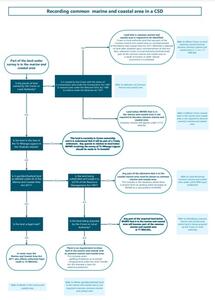
Requirement to identify common marine and coastal area
In certain circumstances land that is part of the marine and coastal area or coastal marine area will need to be identified as a parcel of common marine and coastal area.
The requirements to identify land as common marine and coastal area:
- come from the MACAA and the RMA
- only apply to some parcels adjoining or covered by tidal water
- vary depending on the purpose of the survey and the ownership of the land
- apply even where the rules otherwise appear to allow an existing tidal boundary to be accepted
- cannot be waived by the Surveyor-General by way of a dispensation under s 47(5) of the Cadastral Survey Act 2002.
The overarching questions that need to be answered to determine if land is required to be depicted as common marine and coastal area are:
- did any land in the parcel become common marine and coastal area when the MACAA commenced, or since it commenced?
- are any portions of land in the parcel that are in the marine and coastal area or coastal marine area required to become common marine and coastal area?
In order for these questions to be answered it is important to:
- understand key parts of the MACAA and the RMA, including relevant terms and definitions
- know the purpose of the survey and what legislation it is being done under
- understand aspects of the ownership of the land
- understand where to find relevant information in the applicable regional coastal plan
- assess the site in question to see if any land in the parcel is in the marine and coastal area or in the coastal marine area (that is, seaward of the current line of MHWS)
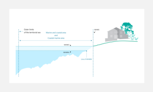
Figure 2: Beach profile showing the extent of coastal marine area/marine and coastal area
The MACAA
- accords a special status to the common marine and coastal area, which prevents the Crown and any other person from owning it (s 11 MACAA)
- has a significant impact on the manner in which land below mean high water springs (MHWS) is to be dealt with when the land is under survey
- amended s 237A of the RMA which has an impact on land being subdivided
- impacts differently on land held in fee simple estate by a private owner than it does on land held by the Crown or a local authority.
To understand which land is affected, and how it is impacted, it is necessary to understand the definitions of the following terms:
- coastal marine area (s 2 RMA)
- common marine and coastal area (s 9 MACAA)
- marine and coastal area (s 9 MACAA)
- mouth (s 2 RMA)
- specified freehold land (s 9 MACAA)
The definitions of these terms can be seen by clicking on the links, or by referring to:
Key terms and abbreviations
Note that not all tidal waterways will form part of the above areas. Only certain parts of the beds of tidal rivers are part of the coastal marine area and hence the marine and coastal area. This largely depends on the position of the mouth.
The term mouth is defined in section 2 of the RMA. Investigation of Regional Council websites/coastal plans and other related information may be necessary to determine the position of the mouth in order to determine the extent of the coastal marine area. These mouth positions have been determined by regional and territorial authorities and the Department of Conservation. In some cases, the extent of the coastal marine area is also specified.
The following are some examples coastal marine area boundaries and mouth descriptions. Note that these may now be out of date and the current Regional Coastal Plan must be consulted for authoritative information.
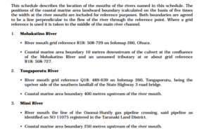
Figure 3: Excerpt from Appendix II of the Regional Coastal Plan for Taranaki 1997
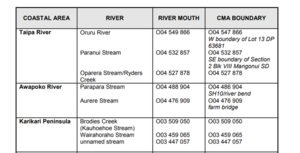
Figure 4: Excerpt from Appendix 1 (Far North District) of the Regional Coastal Plan for Northland 2004
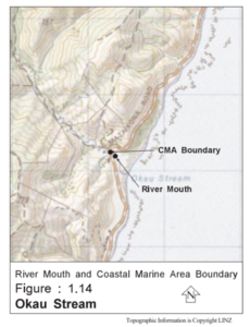

Figure 5: Excerpts from Appendix 1 of the Regional Coastal Plan for the Wellington Region – May 2000
When a parcel that is to be subject to survey has land that is below MHWS, the above terms need to be considered to determine whether that land is part of one or more of the following:
- the coastal marine area/marine and coastal area
- the common marine and coastal area.
For example, both parcels shown in Figure 6 have land that is currently below MHWS. This is indicated by the blue hatched areas. If a check against the relevant Regional Coastal Plan shows that the land covered by water is considered part of the coastal marine area, that portion of the parcel is part of the marine and coastal area.
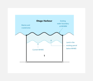
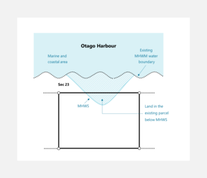
Figure 6: Where land in a parcel is below MHWS
Whether the land in the example above is required to be shown as being or becoming common marine and coastal area on a CSD depends on the status and ownership of the land, and the purpose of the survey. Various scenarios are covered below.
Where land in the marine and coastal area is not required to become common marine and coastal area
The following sections outline situations where land that is in the marine and coastal area is not required to become common marine and coastal area when it forms part of a parcel being surveyed.
Where specified freehold land in the marine and coastal area is not required to become common marine and coastal area
There are scenarios where parcels being surveyed contain one or more portions of specified freehold land below MHWS that is in the coastal marine area (and hence the marine and coastal area) but is not required to become common marine and coastal area.
This includes when the specified freehold land is being surveyed to:
- uplift limitations without being part of a subdivision
- claim accretion without being part of a subdivision
- redefine an existing parcel of land for the purposes of calling for an updated title
- enable the Crown or local authority to acquire land. In this instance common marine and coastal area is not required to be removed from land that is remaining in private ownership but must be removed from the portion which is being acquired. For more information see:
Identifying common marine and coastal area where land is being acquired by the Crown or local authority
If a portion of the parcel being surveyed is in the marine and coastal area and is not required to become common marine and coastal area, the parcel boundary will continue to be to the existing legal description and the whole of the parcel is required to be accounted for. In this instance an existing water boundary can be treated is it would be for non-tidal waters. Any common law erosion that has occurred will need to be removed if rule 10(2)(a) applies. This erosion will be from the existing water boundary position, to the current position of the same legal description. For example from MHWM to MHWM, or MHWS to MHWS.
Where this occurs to a parcel of specified freehold land on a CSD that is not being prepared for a subdivision or to acquire land, the erosion parcel:
- does not need to be annotated “Common marine and coastal area”
- must not have an appellation and instead be annotated “Erosion” as required by rule 103
- must have the parcel intent of 'Erosion' (not the parcel intent of 'Common Marine and Coastal Area (Sec 237A(1)(b) RM Act)').
When one or more parcels in a CSD has land in the coastal marine area/marine and coastal area it is useful for the report to cover this. Reporting should include any decisions made, including the reasons why such land has or is not becoming common marine and coastal area. Clear and thorough reporting is essential to allow staff validating the CSD and future users of the dataset to understand the purpose of the survey and the decisions made.
For more general water boundaries information including see:
Water boundaries
Where Crown-owned land in the marine and coastal area is not required to become common marine and coastal area
When a Crown-owned parcel is under survey and had the status of any of the following kinds at the date that the MACAA commenced:
- a conservation area within the meaning of section 2(1)
of the Conservation Act 1987 - a national park within the meaning of section 2
of the National Parks Act 1980 - a reserve within the meaning of section 2(1)
of the Reserves Act 1977
land below MHWS that is in the marine and coastal area did not become common marine and coastal area under s 11 MACAA. This is due to Crown-owned land with these statuses being excluded from the definition of common marine and coastal area in s 9 MACAA.
However, if a survey is being prepared to transfer or vest the land in an entity other than the Crown, it is unlikely that any land in the marine and coastal area would be included in such a parcel. If land in the marine and coastal area in such a parcel has not been divested from the Crown under s 11 MACAA because of its status, the parcel boundary will continue to be to the existing legal description and the whole of the parcel is required to be accounted for.
Any erosion to a water boundary will need to be dealt with if required by rule 10(2)(a). This erosion will be between the existing water boundary position, and the current position of the same legal description. For example, MHWM to MHWM, or MHWS to MHWS.
Where this occurs to a parcel of Crown-owned land which is not affected by s 11 MACAA because of its status, the erosion parcel:
- does not need to be labelled “Common marine and coastal area” because there is no statutory requirement for land below MHWS to be identified as common marine and coastal area
- must not have an appellation and instead be annotated “Erosion” as required by rule 103
- must have the parcel intent of ‘Erosion’.
When one or more parcels in a CSD has land in the coastal marine area/marine and coastal area it is useful for the report to cover this. Reporting should include any decisions made, including the reasons why such land has or is not becoming common marine and coastal area. Clear and thorough reporting is essential to allow staff validating the CSD and future users of the dataset to understand the purpose of the survey and decisions that were made.
For more general water boundaries information see:
Water boundaries
The bed of the Te Whanga Lagoon in the Chatham Islands
This land is currently in Crown ownership as a result of the Foreshore and Seabed Act 2004. It is understood that it is intended to be part of a future Treaty settlement. Any queries in relation to land below MHWS involving the survey of Te Whanga Lagoon should be made to Te Arawhiti.
Where land in the coastal marine area or marine and coastal area will need to be shown as being or becoming common marine and coastal area
The following are three scenarios where a parcel under survey contains land in the marine and coastal area which needs to be identified as being or becoming common marine and coastal area:
- Land that is required to become common marine and coastal area upon subdivision
Section 237A(1)(b) RMA requires a survey plan of land being subdivided to show any part of the allotment that is in the coastal marine area as part of the common marine and coastal area.
See Land becoming common marine and coastal area under s 237A RMA upon subdivision - Crown and local authority land which became common marine and coastal area on 1 April 2011
Crown and local authority land that met the definition of both marine and coastal area and common marine and coastal area became part of the common marine and coastal area upon commencement of the MACAA.
See Where Crown or local authority owned land has become common marine and coastal area (s 11 or s 13 MACAA) - Specified freehold land being acquired by the Crown or local authority
Where a parcel of specified freehold land is being surveyed because land is being acquired by the Crown or local authority, any land in the marine and coastal area that is part of the land being acquired needs to be shown as becoming common marine and coastal area.
See Identifying common marine and coastal area where land is being acquired by the Crown or local authority
Recording parcels of common marine and coastal area
It is important that the parcels that have become or are becoming common marine and coastal area are recorded correctly. Failure to do so may result in the CSD being unable to achieve its desired purpose.
Key requirements for recording a new primary parcel of land that has or will become common marine and coastal area include:
- whether the parcel is required to have an appellation
- assigning the correct parcel intent for the parcel
- showing annotations including “Common marine and coastal area” and “Erosion” as appropriate.
The way a parcel of common marine and coastal area is recorded in a CSD depends on whether it:
- has already become common marine and coastal area under the MACAA (applies to some Crown and local authority land)
- will become common marine and coastal area as part of the current survey, for example an acquisition of specified freehold land by the Crown or local authority, or a subdivision of the land, and which legislation applies.
The following sections must be consulted to determine whether the new primary parcel is required to have an appellation, along with other requirements:
- Recording land becoming common marine and coastal area under s 237A RMA upon subdivision
- Recording land that has become common marine and coastal area from a parcel of Crown or local authority owned land that has or will have a record of title (s 11 or s 13 MACAA)
- Recording land that has become common marine and coastal area from a parcel of Crown or local authority owned land that will not have a record of title (s 11 or s 13 MACAA)
- Recording land becoming common marine and coastal area where land is being acquired by the Crown or local authority (s 17 MACAA)
Note that parcels are only required to be shown with an annotation of “Common marine and coastal area” when the land has either become common marine and coastal area as a result of the MACAA or is required to become common marine and coastal area under s 237A of the RMA or s 17 MACAA.
Land becoming common marine and coastal area under s 237A RMA upon subdivision
The following information relates to the survey of land that is to be subdivided where part of the land is in the coastal marine area (and therefore marine and coastal area).
The Marine and Coastal Area (Takutai Moana) Act 2011 made significant changes to s 237A of the Resource Management Act 1991 (RMA).
Section 237A(1)(b) RMA requires a CSD of land being subdivided to show any part of the allotment that is in the coastal marine area as part of the common marine and coastal area.
Also, where any part of the base land of a unit title development is in the coastal marine area, a separate Land Transfer (LT) Subdivision CSD showing that land as common marine and coastal area must be approved before a unit plan can be submitted for approval under Section 223 Resource Management Act 1991.
Details of how this land must be shown in a CSD are below.
Many existing parcels surrounding the marine and coastal area have water boundaries set at MHWM. Given the impacts of both common law and statutes such as the MACAA and RMA, there are various scenarios that might apply to a parcel that appears to have one or more portions of land in the marine and coastal area.
For further information on such scenarios see:
Accounting for differences between the existing boundary and current MHWS when common marine and coastal area is required to be shown in a CSD
Recording land becoming common marine and coastal area under s 237A RMA upon subdivision
Where a portion of land is to become part of the common marine and coastal area under s 237A RMA, the survey diagram and title diagram must depict the:
- land as a new primary parcel which must have
- an appellation (such as Lot 3)
- an area (r 83 & r 97)
- the annotation “Common marine and coastal area” or where applicable “Erosion (common marine and coastal area)” (r 87, r 103 and s 237A RMA)
- the Landonline parcel intent of 'common marine and coastal area (s 237A(1)(b) RMA)’
- existing water boundary that is in common with the adjoining water body as an accepted boundary and in relationship to other boundaries (r 15(3), r 85, & r 100)
- new water boundary at a scale that clearly shows its shape and relationship to other boundaries (r 85 & r 100))
- description of the physical feature for the new water boundary (r 88)
- description of the legal water boundary, for example “MHWM” or “MHWS” as applicable (r 104)
- name or simple description of the adjoining water body (r 103).
The “Common marine and coastal area” annotation, in conjunction with the new primary parcel enables the CSD to comply with s 237A RMA.
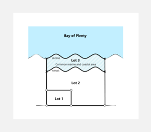
Figure 7: Where specified freehold land is being subdivided
For information on Crown subdivisions see:
Crown Subdivisions CSDs
Where Crown or local authority owned land has become common marine and coastal area (s 11 or s 13 MACAA)
The following information relates to the survey of land owned by the Crown or a local authority where part has become common marine and coastal area under the MACAA.
Land below MHWS owned by the Crown or a local authority at the time the MACAA commenced became part of the common marine and coastal area s 11 MACAA except where that land was owned by the Crown and had the status of any of the following kinds:
- a conservation area within the meaning of section 2(1) of the Conservation Act 1987
- a national park within the meaning of section 2 of the National Parks Act 1980
- a reserve within the meaning of section 2(1) of the Reserves Act 1977 (s 9 MACAA).
This change occurred without the need for surveys or legalisation action, so survey and title records do not necessarily reflect the changes. This means that a parcel of local authority or Crown-owned land (excluding the exceptions listed in the bullet points above) which originally extended down to MHWM no longer contains the portion below MHWS. However, this will only be reflected in the cadastre and on the title when the land is eventually surveyed.
Note that the exceptions in s 11 MACAA only refer to Crown-owned conservation area, national park or reserve (see above). That is, land that was in the marine and coastal area upon the commencement of the Act in a local authority reserve prior to the Act coming into force is deemed to have become common marine and coastal area at that time.
In some cases the MACAA also affects unformed legal roads (s 14 MACAA).
For further information see:
Roads in the marine and coastal area
The MACAA says Crown or local authority land previously above MHWS that becomes part of the marine and coastal area as a result of erosion or other natural occurrence becomes part of the common marine and coastal area (s 11(4) MACAA). The change due to natural occurrences does not need to be gradual or imperceptible.
These requirements apply to parcels with fixed boundaries as well as parcels that do not adjoin the sea (s 13(2) MACAA).
For further information on various scenarios that may be encountered see:
Accounting for differences between the existing boundary and current MHWS when common marine and coastal area is required to be shown in a CSD
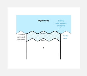
Figure 8: Common marine and coastal area as a residue parcel
Where Crown or local authority land has or will have a record of title
Where land owned by the Crown or a local authority (except that excluded from the definition of common marine and coastal area due to its status – see above) is held, or will be held, in a record of title, land below MHWS in the marine and coastal area is to be identified as a residue parcel to reflect the divesting of a parcel of common marine and coastal area (s 11(3) & s 23 MACAA).
Recording land that has become common marine and coastal area from a parcel of Crown or local authority owned land that has or will have a record of title (s 11 or s 13 MACAA)
In these situations, the survey diagram and title diagram must depict the:
- the new primary parcel/s containing the common marine and coastal area:
- as a residue parcel without an appellation (s 23(3) MACAA)
- with the annotation “Common marine and coastal area” or where applicable “Erosion (common marine and coastal area)” (r 87 & 103)
- with the Landonline parcel intent of 'hydro’, or where applicable ‘erosion’. (r 92(f))(e) & s 23 MACAA).
- existing water boundary that is in common with the adjoining sea as an adopted or accepted boundary in relationship to other boundaries (r 15(3), r 85, & r 100)
- new water boundary at a scale that clearly shows its shape and relationship to other boundaries (r 85 & r 100)
- description of the physical feature for the new water boundary (r 88)
- description of the legal water boundary, for example “MHWM” or “MHWS” (r 104)
- name or simple description of the adjoining water body (r 103).
The “Common marine and coastal area” annotation, in conjunction with the new primary parcel enables the CSD to demonstrate compliance with the MACAA and the schedule 2 (CSR 2021) definition of residue parcel.
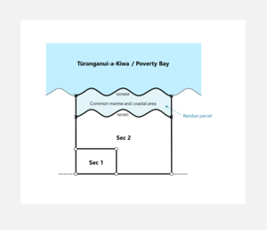
Figure 9: Where Crown or local authority land is in a record of title
Figure 9 above shows an example of a proposed legalisation action affecting land held in a Record of Title and owned by the Crown or a local authority – Section 1 is to be set apart for a public work, while Section 2 is the remainder of the land that will continue to be owned by the Crown or local authority and held in a Record of Title. The common marine and coastal area is identified as a residue without an appellation.
Where Crown or local authority land will not have a record of title
Where land owned by the Crown or a local authority (except Crown land that is excluded from the definition of common marine and coastal area due to its status - see above) is not held or will not be held in a record of title and is:
- to be disposed of or is being identified for a legalisation action (including a public work or a statutory vesting), the portion that has become common marine and coastal area is to be identified as a separate residue parcel
- to continue to be owned by the Crown or a local authority where its status will be unaffected by the legalisation or vesting, there is no need to separately identify any portion below MHWS. Instead, where the boundary is MHWM, it is to be annotated “Boundary affected by Marine and Coastal Area Act 2011”. Note that because the divested common marine and coastal area (refer to s 11(3) & s 23 MACAA) has not been identified, the parcel as defined in the SO (survey office) CSD may not be suitable for issue of a record of title should this be required in the future.
Recording land that has become common marine and coastal area from a parcel of Crown or local authority owned land that will not have a record of title (s 11 or s 13 MACAA)
The survey diagram and title diagram must depict the:
- new primary parcel/s containing the common marine and coastal area:
- as a residue parcel without an appellation (s 23(3) MACAA)
- with annotation “Common marine and coastal area” or where applicable “Erosion (common marine and coastal area)” (r 87 & 103)
- with the Landonline parcel intent of 'hydro’, or where applicable ‘erosion’. (r 92(f))(e) & s 23 MACAA).
- existing water boundary of the new residue parcel that is in common with the adjoining sea as an adopted or accepted boundary in relationship to other boundaries (r 15(3), r 85, & r 100)
- existing water boundary of the land that is unaffected by the legalisation or vesting as an adopted or accepted boundary in relationship to other boundaries and with the annotation of “Boundary affected by Marine and Coastal Area Act 2011” (r 15(3), r 85, & r 100)
- new water boundary at a scale that clearly shows its shape and relationship to other boundaries (r 85 & r 100)
- description of the physical feature for the new water boundary (r 88)
- description of the legal water boundary, for example “MHWM” or “MHWS” (r 104)
- name or simple description of the adjoining water body (r 103).
The “Common marine and coastal area” annotation, in conjunction with the new primary parcel enables the CSD to demonstrate compliance with the MACAA and the schedule 2 (CSR 2021) definition of residue parcel.
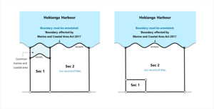
Figure 10: Crown or local authority land not in a record of title.
In Figure 10 above, the land is not held in a Record of Title. The diagrams show Section 1 identified for a legalisation action such as to be set apart for road or vested as part of a Treaty settlement.
In the diagram on the left, the intention is to acquire the western portion of land, extending to the common marine and coastal area.
In the diagram on the right, only the southwestern portion of land is to be acquired, leaving some land remaining between the acquired portion and the common marine and coastal area.
In both cases, the ownership and status of Sec 2 is to remain unchanged and therefore the land below MHWS is not shown, but the MHWM boundary is annotated “Boundary affected by Marine and Coastal Area Act 2011”.
Identifying common marine and coastal area where land is being acquired by the Crown or local authority
The following information relates to the survey of private land that is to be acquired by the Crown or local authority where part of the land is in the marine and coastal area.
Where the Crown or a local authority acquires privately owned land, any part of the acquired land below MHWS that is part of the marine and coastal area becomes on that acquisition part of the common marine and coastal area (s 17 MACAA). This includes land surveyed for legalisation purposes.
Recording land becoming common marine and coastal area where land is being acquired by the Crown or local authority (s 17 MACAA)
Where a portion of land is to become part of the common marine and coastal area because specified freehold land is being acquired by the Crown or local authority, the survey diagram and title diagram must depict the:
- land as a new primary parcel
- with an appellation (such as Section 3) and an area (r 83 & r 97)
- with the annotation “Common marine and coastal area” or where applicable “Erosion (common marine and coastal area)” (r 87 & 103)
- with the Landonline parcel intent of 'hydro’, or where applicable ‘erosion’. (r 92(f))(e) & s 23 MACAA).
- existing water boundary that is in common with the adjoining water body as an accepted boundary and in relationship to other boundaries (r 15(3), r 85, & r 100)
- new water boundary at a scale that clearly shows its shape and relationship to other boundaries (r 85 & r 100))
- description of the physical feature for the new water boundary (r 88)
- description of the legal water boundary, for example “MHWM” or “MHWS” as applicable (r 104)
- name or simple description of the adjoining water body (r 103).
The “Common marine and coastal area” annotation, in conjunction with the new primary parcel enables the CSD to demonstrate compliance with the MACAA and the schedule 2 (CSR 2021) definition of residue parcel.
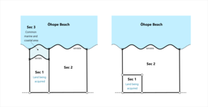
Figure 11: Private land subject to legalisation action
In Figure 11 above, the diagrams show land being acquired above MHWS as Section 1, and land being acquired below MHWS as Section 3 and annotated “Common marine and coastal area”. Section 2 is to remain in private ownership.
In the right-hand diagram, no land will become part of the common marine and coastal area because none of the land below MHWS is being acquired. The existing water boundary will need to be defined by survey, adopted, or accepted as allowed or required by the rules.
Given the impacts of both common law and statutes such as the MACAA, there are various scenarios that might apply to a parcel that appears to have one or more portions of land in the marine and coastal area.
For further information on such scenarios see:
Accounting for differences between the existing boundary and current MHWS when common marine and coastal area is required to be shown in a CSD
Easements over land to become common marine and coastal area
The following information relates to dealing with proposed or existing easements over land that is to become common marine and coastal area upon subdivision or when the Crown or local authority acquire land. It does not relate to situations where Crown or local authority owned land in the marine and coastal area has already become common marine and coastal area.
Proposed easements
There is no mechanism to register a new easement against land in the common marine and coastal area because there is no owner capable of granting an easement.
Existing easements
Where land is being subdivided, the portion of an existing easement that overlaps land that is to become common marine and coastal area is to be surrendered (refer to page 15 of LINZG20726: Registration guideline for the Marine and Coastal Area (Takutai Moana) Act 2011). This surrendered portion is not normally depicted in the CSD diagrams.
In this case, the CSD diagrams must depict the extent of the existing easement that is to be retained.
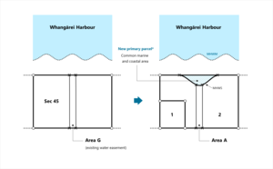
Figure 12: Where existing easement overlaps land to become common marine and coastal area
* For information on parcel intent and appellation see:
Recording parcels of common marine and coastal area
For further information about surrendering easements see:
Surrendering part of an easement or revoking part of a covenant
Accounting for differences between the existing boundary and current MHWS when common marine and coastal area is required to be shown in a CSD
The following section
- outlines various scenarios that may arise when ascertaining the extent of land that has become common marine and coastal area because it was divested when the MACAA came into force or will become common marine and coastal area when specified freehold land is subject to s 237A RMA 1991 or is being acquired by the Crown or a local authority (s 17 MACAA)
- applies to all land independent of land status, ownership or survey purpose
- must be read in conjunction with the sections outlining specific requirements for different land status and ownership.
Where land is required to be identified as being or becoming common marine and coastal area, the CSD will need to include all the land in the existing parcel, that is, right up to the existing legal boundary.
While existing boundaries can take any form of boundary, including right-line. They will often be a water boundary.
Two common legal descriptions for tidal boundaries are MHWM and MHWS. In theory it would seem to be a relatively simple task to identify the land:
- between MHWS and MHWM where the existing boundary is MHWM
- between the former MHWS and the current MHWS if the existing boundary is MHWS.
However, as water bodies are movable, they are often no longer in the same physical position as the survey which previously recorded the related water boundary. Also, some early surveys may not have accurately recorded the location of these water boundaries. These factors have introduced variations in how parcels comprising of common marine and coastal area are to be defined.
When there is land in the parcel that is required to be identified as common marine and coastal area it must be shown as a new primary parcel. The type of parcel (and whether it is required to have an appellation) will depend on the ownership of the land and the purpose of the survey. It is important that any such parcels are shown correctly.
This article explains the following variations:
- Where MHWS coincides with existing MHWM boundary
- Where current MHWS is inland from an existing MHWM boundary
- Where current MHWM is inland from existing MHWM boundary because of erosion
- Where current MHWS is within an inland parcel
- Where current MHWS is seaward of existing MHWM or MHWS because of accretion or avulsion
- Where current MHWS is in a different location due to a poorly-defined existing MHWM
Where MHWS coincides with existing MHWM boundary
The distinction between MHWM and MHWS is legally significant as explained in:
Diagrams must distinguish between MHWS and MHWM
Where the existing boundary position of MHWM is coincident with the current MHWM and also coincident with MHWS, no land has or will become part of the common marine and coastal area. An example of this is where the water boundary is a vertical cliff face that has not eroded and was accurately fixed in the original survey.
In this case, the title diagram must prominently depict the notation “MHWS = MHWM” clearly related to the relevant boundaries (r 104). This notation is one way of demonstrating that no land has become or is required to become common marine and coastal area whilst complying with the CSR 2021.
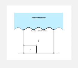
Figure 13: Where existing MHWM and current MHWS coincide
Where current MHWS is inland from an existing MHWM boundary
If the current MHWS is inland from the existing MHWM boundary, the land in the parcel below MHWS needs to be identified as land that has become or is becoming common marine and coastal area.
In this case, the survey diagram and title diagram should depict:
- both the new MHWS boundary and the existing MHWM water boundary (to ensure the whole of the parcel is accounted for (r 39(2))
- the land between MHWS and MHWM as a new parcel with an annotation “Common marine and coastal area”.
To determine whether an appellation is required for the new primary parcel refer to:
Recording parcels of common marine and coastal area
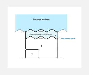
Figure 14: Where current MHWS is inland of existing MHWM
* For information on parcel intent and appellation see:
Recording parcels of common marine and coastal area
Where current MHWM is inland from existing MHWM boundary because of erosion
If, because of erosion, the current MHWM is further inland than the existing primary parcel boundary of MHWM, the surveyor may exercise their judgment (irrespective of rule 10(2)(a)) and show either:
- all of the land between the existing MHWM boundary and the current MHWS position as a new parcel with the annotation “Common marine and coastal area” or
- land between the existing MHWM boundary and the current MHWM position as a residue parcel with the annotation “Erosion (common marine and coastal area)” and the land between the current MHWM position and the current MHWS position in a new parcel with the annotation “Common marine and coastal area”.
To determine whether an appellation is required for the new primary parcel refer to:
Recording parcels of common marine and coastal area
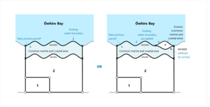
Figure 15: Where erosion affects MHWM
* For information on parcel intent and appellation see:
Recording parcels of common marine and coastal area
Note that if the parcel has an existing water boundary set at MHWS and common law erosion has occurred since that existing boundary was defined, this must be annotated “Common marine and coastal area” where:
- required to be shown by s 237A of the RMA
- where the land is owned by the Crown or local authority and has already been divested under s 11 of the MACAA.
- where specified freehold land is being acquired by the Crown or local authority.
Where current MHWS is within an inland parcel
S 13(2) of the MACAA and s 237A of the RMA apply to parcels with fixed boundaries as well as moveable water boundaries. They could conceivably apply to parcels that did not adjoin the sea when originally defined, if the sea has subsequently encroached.
It is important to understand that the MACAA and RMA have subtly different wording. Section 237A RMA states that where a survey plan is submitted to a territorial authority in accordance with section 223, and any part of the allotment being subdivided is within the coastal marine area, the survey plan shall show any part of the allotment that is in the coastal marine area as part of the common marine and coastal area.
However, section 13 (2) of MACAA states if, because of a change caused by a natural occurrence or process, any land, other than a road, that is owned by the Crown or a local authority becomes part of the marine and coastal area, then that land becomes part of the common marine and coastal area (even if that land consists of or is included in a piece of land defined by fixed boundaries).
Therefore, any changes to the position of MHWS need to have been caused by a natural occurrence or process for the MACAA to apply, whereas the RMA requires all land below MHWS that is in the coastal marine area to be shown as part of the common marine and coastal area.
The following example shows a situation where land in a parcel with a right-lined boundary, that is separated from the water body by another parcel, has land below MHWS.
If the land is owned by the Crown (with the exceptions noted - see above) or local authority and the portion below MHWS has become part of the marine and coastal area due to a natural occurrence or process, that portion has become part of the common marine and coastal area.
If the land is specified freehold land subject to a subdivision, the land below MHWS in the coastal marine area will be required to become common marine and coastal area upon subdivision, regardless of how the land became below MHWS.
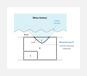
Figure 16: Where current MHWS is within an inland parcel
* For information on parcel intent and appellation see:
Recording parcels of common marine and coastal area
Where land in an inland parcel has or will become common marine and coastal area, the survey diagram and title diagram should depict:
- the new MHWS boundary
- the land between MHWS and the fixed boundary as a new parcel with the annotation “Common marine and coastal area”. To determine whether an appellation is required for the new primary parcel refer to:
Recording parcels of common marine and coastal area
Where current MHWS is seaward of existing MHWM or MHWS because of accretion or avulsion
Where a primary parcel with an existing water boundary at MHWM or MHWS is surveyed and the current MHWS is seaward from this existing boundary because of accretion or avulsion, one of the following scenarios will apply:
- where accretion has occurred but is not being claimed and it has been determined there is no land in the parcel to become part of the common marine and coastal area, the existing water boundary of MHWM or MHWS can be adopted (r 10(2)(b)) or accepted if rule 15(2)(c)(iii) or 15(4) are applicable
- where avulsion has occurred and it has been determined that there is no land in the parcel that has or will become part of the common marine and coastal area, the existing MHWM or MHWS boundary can be adopted (rule 10(3)(a)), accepted if rule 15(2)(c)(iv) or 15(4) is applicable or may be converted to one or more right-line boundaries (rule 10(3)(b)).
For both of these scenarios the survey diagram and title diagram should depict:
- the adopted water boundary in its existing position at a scale that clearly shows its shape and relationship to other boundaries of the parcel (r 85 & r100)
- the annotation “MHWM” or “MHWS” as appropriate along the existing water boundary
- the annotation “Adopted boundary not coincident with water’s edge” where accretion has occurred but is not being claimed and the water boundary is being adopted using rule 10(2)(b), (r 104)
- the annotation “Former water boundary not coincident with water’s edge” where avulsion has occurred and the existing water boundary has become an irregular boundary under rule 10(3)(a), (r 104)
- enough information so that it is obvious that the MHWM title boundary is not coincident with MHWS and that MHWS is further out to sea. This should be achieved by adding an annotation to the title diagram such as “Current MHWS is approximately 20m seaward of the MHWM boundary” (rules 28 & 97(1)(a)).
Where avulsion has occurred and the existing water boundary has been converted to one or more right lines, an annotation is not required by the rules. However, it must be very clear either by a note in the survey report or on the plan face that there is no land in the parcel that is required to become common marine and coastal area.
The left-hand diagram of Figure 17 below illustrates the scenario where accretion has occurred but is not being claimed.
For more information about avulsion scenarios, including claims for dry bed, see:
Avulsion, artificial diversion and reclamation
If the existing boundary is MHWM and a claim is being made for accretion, the claim is to be made to the current MHWM and the land between current MHWM and current MHWS is to be identified as land that has or will become part of the common marine and coastal area. For specific rule requirements on the depiction of a parcel of land that has or will become common marine and coastal area including whether the primary parcel created must have an appellation see:
Recording parcels of common marine and coastal area
This is illustrated in the right-hand diagram of Figure 17 below.
Note that:
- if the existing water boundary is MHWS and a claim is being made for accretion, the claim is to be made to the current MHWS and there will not be land becoming common marine and coastal area.
- to determine whether an appellation is required for the new primary parcel refer to:
Recording parcels of common marine and coastal area - general requirements relating to depicting accretion can be found in the following article:
Where accretion is claimed
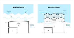
Figure 17: Where there is accretion
* For information on parcel intent and appellation see:
Recording parcels of common marine and coastal area
Where current MHWS is in a different location due to a poorly-defined existing MHWM
There may be cases where there is strong evidence that an existing MHWM boundary was inadequately defined and a better survey fix is appropriate. In this situation there will be land in the parcel that has or will become part of the common marine and coastal area unless MHWS and MHWM are considered to be coincident
Before using this method a surveyor should fully understand the concept of a better survey fix. A 'better fix' implies that the:
- position of MHWM has not moved since the original survey
- historic MHWM boundary was not an accurate portrayal of the boundary as it was on the ground at the time of the original survey
- later better fix is a better portrayal of that same boundary in the position it was at the time of the original survey.
For more information see:
Better survey fix
Evidence to support the use of the 'better fix' must be recorded in the survey report.
In this case, the new MHWS position should be defined by survey and the survey diagram and title diagram should depict:
- the new MHWS boundary
- a 'better fix' of MHWM seaward of the new MHWS. This MHWM can be an approximation under rule 29(2) given it is a disappearing boundary. The old inaccurate MHWM must not be shown
- the land between the current MHWS and the new seaward MHWM as a new parcel with an annotation “Common marine and coastal area”.
To determine whether an appellation is required for the new primary parcel refer to:
Recording parcels of common marine and coastal area
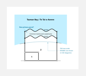
Figure 18: Where MHWS is seaward because of poor historic fix of MHWM
* For information on parcel intent and appellation see:
Recording parcels of common marine and coastal area